... His lips are moving, goes the old joke. An alternative answer at the moment might be that he is explaining to you the reasons for Peter Batty's departure from Intergraph. I have heard from my friends in the Intergraph utility team that competitive salespeople have been telling customers that I left Intergraph because they are pulling out of the utility business, and I just wanted to say that this is complete nonsense. The utility business is one of Intergraph's most profitable areas, and Intergraph has some strong momentum there right now and is very committed to the business. I think that Intergraph is very strongly positioned in the utility market currently. I'll write more about my perspectives on the utility business at some point soon, but I just wanted to try to squash that rumor.
I'm in New Orleans for Jazzfest the next few days, so hopefully will not be posting too much until next week!
Thursday, April 26, 2007
Tuesday, April 24, 2007
The Day ArcIMS Died
James Fee has an interesting post on "The Day ArcIMS Died", talking about the impact of Arc2Earth Publisher. I think that aside from the obvious impacts that Google and Microsoft are having on the geospatial industry, a more subtle one is that they are helping to crack the unswerving devotion that most traditional GIS users have generally had to their selected vendor.
Google and Microsoft have such a high profile that it is hard for even the most insular organizations to ignore what they are doing. My hope for the industry is that this will help open people's eyes to the fact that there may well be better solutions out there than their current vendor provides, not just from Google and Microsoft but also from other companies or open source initiatives, so I think we will start to see more organizations selecting software based on its merits, rather than just choosing their incumbent vendor without doing any real evaluation. There was another interesting debate on James' blog a little while ago on the topic of "Are we begining to see a shift away from ESRI Server backend to Open Source solutions?", and one of the comments there said "I work for a US government agency that is getting ready to send out a RFP for GIS servers that has no ESRI requirement. A first for us". This type of increased competition will only be good for end users.
I think that traditional geospatial vendors who do not embrace and leverage what Google and Microsoft are doing, but try to fight them, are fighting a losing battle. Heterogeneous geospatial systems will be much more common than they have in the past.
Monday, April 23, 2007
How news spreads
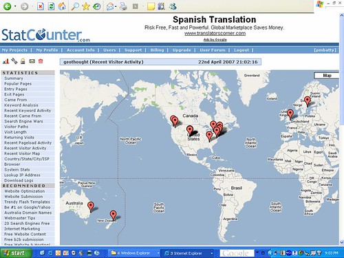
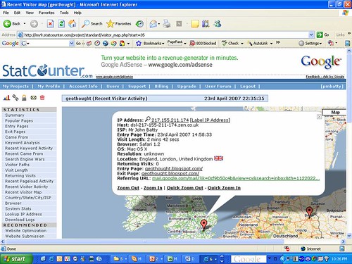
Just before I launched my blog, I added in some tracking capabilities from StatCounter. This is probably old hat to all you seasoned bloggers and webmasters out there, but I was really pretty impressed with the amount of detail this provided, including a Google maps based display of where visitors were coming from, as well as the referring web page, if any. Below is a map from Sunday evening showing recent visitors. This was before any widespread announcement of my departure, but it was announced to Intergraph on Thursday last week so word had obviously got out a little, and most of these hits were links from my personal site ebatty.com, where I added a link to my new blog on Saturday night. But in several cases I would see a hit from someone who had followed a link from ebatty, followed by several more from the same area, or company, with no referring web link, which presumably meant that the direct link to the blog had just been passed on by email.
- No referring link - 346 page impressions
- Linked from All Points Blog - 82 page impressions
- Linked from GISuser - 36 page impressions
- Linked from Planet Geospatial - 16 page impressions
This may only be of interest to me, but the other sport today was seeing whether the blog would get more hits from ESRI or Intergraph. The results were:
- ESRI - 57
- Intergraph - 46
- General Electric (home of Smallworld) - 31
I guess this makes sense since it wasn't new news to Intergraph people - or perhaps they were all just busy doing productive work unlike those ESRI guys who obviously sit around surfing the web all day ;) !!
One issue with the Statcounter maps, which is a pet peeve of mine with various online mapping sites, including Google MyMaps and Yahoo Maps, is that when you need to display a lot of markers, the map display is split into multiple "pages" with a different set of markers on each (split arbitrarily between pages). Even if you zoom into a small area, you have to flip though multiple pages to see all relevant markers for that area. It really shouldn't be that difficult to set things up in such a way that as you zoom in, and reduce the number of markers which need to be displayed, you do away with the multiple "pages" - this would be much more useful. A simple generic solution to this issue would be a good thing!!
And finally, in total my new blog got hits from 22 countries and 33 states in its first 14 hours of public existence, which is not bad for its first day ... I'm sure the novelty of these tracking statistics will have worn off by tomorrow and I won't go on about this sort of stuff any more (though I would quite like to produce a time sequenced KML file showing the spread of news ... will put than on my list of educational projects to play with).
Virtual Earth 3D in New York??
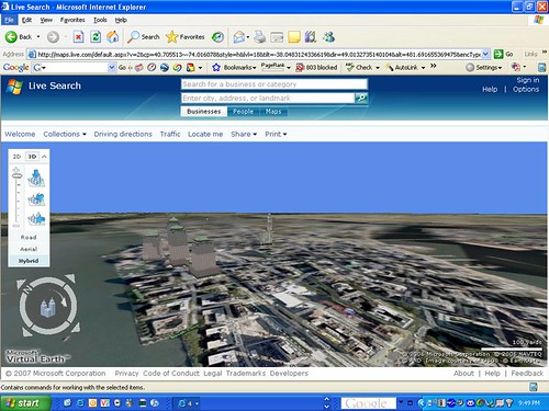
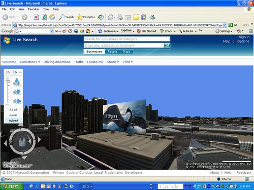
I have heard from several Microsoft people that they had created a 3D model of New York City but it just hadn't gone online yet. So I was pretty excited to see the Virtual Earth for Government blog announce that this was now live and "man is it ever cool" - and they have a very cool screen shot to back it up. But sadly when I flew over to New York, I just saw a handful of 3D buildings on a flat map :( ... hopefully it will be there for us non-Microsoft people soon, but not quite yet I guess.
Saturday, April 21, 2007
New navigation / LBS devices
I recently bought two new navigation / LBS (Location Based Service) devices, each with integrated GPS and wireless communications. One cost $299.99 (with a 2 year contract), a Blackberry 8800, and the other cost around $27,000, a Toyota Prius. In addition to its LBS capabilities, the Prius also provides functionality to transport you to your chosen location in an environmentally friendly way :).
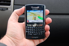
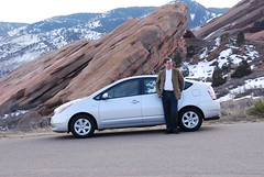
I have been very impressed with both. I have written in the past about the geotechnology in my previous car, an Infiniti FX35, and the navigation system in my Prius provides a significant jump in functionality and ease of use from the (three year old) one in my Infiniti. I'll probably write a more detailed review on this in future, but you can see a few photos of both the Prius and the BlackBerry in action to get an idea. Just like the BlackBerry, the Prius includes integration with a telephone, and the photos show an example where I used my car to track down the nearest Cingular store which had a BlackBerry 8800 in stock, using the integrated dialing features to call the stores in order of distance from my current location. And by the way, the Prius drives really nicely too, and does 45-50 mpg - I highly recommend it!
I have also been very impressed by the BlackBerry 8800 so far, and in particular by the telenav application which uses the built in GPS. It has rich functionality and a simple user interface. So far I have found the database of businesses to be very complete and up to date. Last week in Huntsville I was going to a baseball game with a group of people from work, and I just searched for "baseball" and it returned not only the Huntsville Stars stadium, which is where I wanted to go, but also the Huntsville Sports Academy (which is a baseball school but does not include baseball in the name), which moved to a new location just three months ago, and telenav showed it at the correct address. When you navigate a route, it automatically downloads information on the route in advance to ensure good performance - though I have found the EDGE wireless network performance to be very good in general. It gives you voice directions which are loud and clear and even says street names (e.g. "Turn left on 20th street"), which most navigation systems don't do. Telenav also offers Telenav Track, a very reasonably priced mobile workforce management system. I plan to look at that in more detail, but I think that this type of device and application could be very disruptive to traditional workforce management systems, which are typically fairly large and complex enterprise software systems.
Both the Prius and the BlackBerry are good examples of the continuing integration of sophisticated location based technology into mainstream devices. I see great potential for the BlackBerry and similar devices, and will write more about other location based applications for it in future posts, including BlackBerry Maps, Google Maps for Mobile, and Spot for BlackBerry, the last of which claims an impressive list of features, including the ability to record tracklogs (something I want in order to be able to geotag my photos using RoboGeo without needing a separate handheld GPS), and even the ability to read data from WMS servers! More to come ...
Friday, April 20, 2007
Goodbye and good luck to Intergraph
Yesterday was my last day working for Intergraph, where I have held the role of Chief Technology Officer for the past 18 months. I very much enjoyed my time at Intergraph and was sorry to leave in many ways - I worked with a lot of great people there and will miss them. But I had really grown tired of the traveling - for personal reasons I am not in a position to move from Denver, so I was traveling to Huntsville, Alabama, every second week or so, and generally somewhere else in the intervening weeks. While I enjoy travel and have been to some great places along the way, it's tough to keep up that sort of schedule forever. You can see where I went using Google Earth here, or using Google Maps here for North America, and here for the rest of the world (needed to split the Google Maps version as it won't handle a single KML file this large).
Secondly, I decided I would really like to get back to a role where I have more hands-on involvement with technology, probably in a startup or small company environment ... I may well start my own company, and have a few ideas I'm exploring, but will think about my options for a while. I'm open to interesting offers or discussion of ideas :) !!
I think we made some good progress in various areas during my time at Intergraph, and there are some great people in place to take over the things I was working on, so I look forward to seeing Intergraph continue to be successful.
Hello World
I've been contemplating starting a blog for quite some time, even before Adena at All Points Blog encouraged me to do so over a year ago. But things were pretty hectic in my role as CTO of Intergraph, and I never quite got round to it. But since yesterday was my last day at Intergraph, I thought this was as good a time as any to get things rolling. I plan to post my thoughts on the rapidly changing world of geospatial and location technologies. Welcome, and please let me know if you have suggestions for things I should talk about.
Subscribe to:
Posts (Atom)