Showing posts with label neogeography. Show all posts

Wednesday, November 4, 2009

I've joined the Advisory Board of FortiusOne

Today it was announced that I've joined the new Advisory Board of FortiusOne, together with Jeff Harris, who has a very distinguished background in the Intelligence world, and Michael Frankel and Wolf Ruzicka, who bring great expertise in Business Intelligence and enterprise software. We actually had the first Advisory Board meeting just recently and it's a great group.

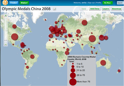
I've followed the development of FortiusOne with interest for a few years now, and I did a bit of consulting for them back in the fairly early days of the company. Their CEO Sean Gorman and CTO Andrew Turner are two of the leading thinkers in the geospatial industry. I am a big proponent of their philosophy of de-mystifying geospatial analysis and making it accessible to a much broader audience of non-specialists. You can check out their free GeoCommons site which lets you easily search for, upload and download geospatial data, and produce great looking maps and spatial analysis like this:


(Click on the map to go to the interactive version)

One cool feature of GeoCommons is the ability to upload spreadsheets containing addresses or place names, which will be automatically geocoded using the free and open source GeoCommons geocoder. There are lots of nice examples of using GeoCommons on the FortiusOne blog, for example these posts on health care, the Afghan Elections, and home foreclosures. FortiusOne sells enterprise versions of their application (as a service or an appliance), which have additional analytic capabilities beyond those on the free public site, but with the same focus on simplicity and ease of use. I look forward to working with the team at FortiusOne, and watch for more cool new things coming soon!

Monday, October 26, 2009

Talk on "The Geospatial Revolution" in Minnesota

Here is a video of my recent keynote talk at the Minnesota GIS/LIS conference in Duluth, which was an excellent event. There were about 500 people there, which is great in the current economic climate. It was mainly a "traditional GIS" audience, and I got a lot of good feedback on the talk which was nice.

I talk about current trends in the industry in three main areas: moving to the mainstream (at last!); a real time, multimedia view of the world; and crowdsourcing. There's a lot of the same material that I presented in my talk with the same title at AGI GeoCommunity (which doesn't have an online video), but this one also has additional content (~50 minutes versus 30 minutes).

Click through to vimeo for a larger video, and if you click on "HD" you will get the full high definition version!! I used a different approach to produce this video compared to previous presentation videos, using a separate camera and a different layout for combining the slides and video. I like the way this came out - I'll do a separate blog post soon with some tips on how to video presentations, I think.

The Geospatial Revolution (Minnesota) from Peter Batty on Vimeo.

You can also view the slides here:

Tuesday, July 28, 2009

Are we now in the post-neogeography era?

So all the discussion about my last post got me to thinking about how to define "neogeography". I was really using it in a pretty broad sense, as a convenient label for the “new generation” of web mapping tools and related technologies that have emerged over the past few years – essentially the “disruptive technology” that Clayton Christensen talks about. These systems include Google Maps and Earth, Virtual Earth, Yahoo Maps, and various offerings from smaller players. However, I feel that the distinction between “neogeography” and “GIS” is becoming increasingly blurred, to the point where it really doesn’t make much sense to even try to make a distinction in many cases.

As I discussed, “neogeography” systems are now increasingly being used for more activities that were in the domain of “traditional GIS”, including cartography, analysis and data creation. And “GIS” is increasingly using ideas that originated in neogeography systems, like using pre-rendered raster tiles for fast map rendering, implementing REST APIs, etc. The summary for O'Reilly's "Introduction to Neogeography", which is probably as good a source as any, says "Neogeography combines the complex techniques of cartography and GIS and places them within reach of users and developers". So according to that definition it's really about simplification, which is certainly a key characteristic of systems like Google Maps and Virtual Earth. But it's obviously not a hard and fast definition, and many efforts within the traditional GIS space could be said to have done the same thing, especially more recently as ideas have been taken from the first round of "neogeo" products.

I think that one other difference between those who describe themselves as neogeographers and those who describe themselves as GIS professionals is that the former see geospatial data as just another data type, whereas the latter tend to see it as something more specialized. But this also a continuum, and this difference in philosophy has been around in the industry to a large extent since well before neogeography arrived on the scene (but maybe with a smaller proportion of those with the first opinion).

So to me, the main point is that there is now a broader set of tools available to help address geospatial problems, regardless of what you call them. I think that many people in the traditional GIS world haven’t had too much exposure to these new tools, and a lot of people still have the mindset that they have selected a primary GIS vendor – ESRI, Intergraph, Smallworld or whoever – and they should only use geospatial software from that vendor as it will make their life easier. But it is really very easy to mix and match geo software tools these days, so it’s worth looking around at the various new options. But clearly there are still many tasks for which the best choice remains the current generation of traditional GIS. However, the traditional GIS vendors will face major price pressure over the next few years as the newer generation of simpler and cheaper systems mature.

So in summary I really don’t see much value in trying to define some tools as “neogeography” and some as “GIS” – to me it’s all just geospatial technology and you should choose the right tools for a given job. Maybe the term "neogeography" has outlived its usefulness and it should just quietly fade away, except as a historical term to describe the new geospatial systems that emerged in the past few years, before they interbred with traditional GIS and became just part of the new and richer set of tools that is now available for geospatial applications? Or we just regard terms like neogeography, GIS and geospatial technology as synonymous?

Twitter discussion on "neogeography" versus "GIS"

My post yesterday triggered some interesting discussion on Twitter (I guess the cool kids don't comment on blogs any more, that's so 2008!). Here's a quick cut and paste with most of the relevant stuff (the relevance fades towards the end but I figured I would leave some of those bits in!). I will post more thoughts shortly on what I think "neogeography" actually is. If you want to figure out who someone is on twitter, just go to twitter.com/username - for example I'm at twitter.com/pmbatty.

cageyjames: @pmbatty isn't all that stuff still very niche? I'm just not seeing the quick pickup you are I guess.
cageyjames: @pmbatty That said I'm coming off #esriuc and you #sotm so we skew on our last experiences. Reality is probably between us.
cageyjames: Of course Neo and GIS are just labels people put on others to limit their growth.
pmbatty: @cageyjames early days still but my point is more rapid growth of neo in areas like cartography, analysis, etc than many people think
pmbatty: @cageyjames I agree I'm not a big fan of labels like neo, paleo, GIS, it's all the same problem space
cageyjames: @pmbatty but can you call that neo? What Stamen is doing isn't neo in my book. You seem to say innovative is neo. That isn't true at all.
cageyjames: @pmbatty When I was taking carto classes back in college, was I neo because I used Freehand over pen and paper? Not in my book.
pmbatty: @cageyjames Stamen is using OSM, Mapnik, Virtual Earth, etc - would think that was "neo" though we agree the label is a bit pointless
geobabbler: @pmbatty Neo is GIS. Just like "desktop mapping" was.
pmbatty: @geobabbler I agree that Neo is GIS - I think that is what I was trying to say but you were more concise :)
geokaren: @pmbatty @geobabbler I think of neo as less rooted in technology and more the concept of moving it beyond traditional GIS
cageyjames: @pmbatty ESRI uses OSM, Virtual Earth and other "neo" packages. That doesn't make them neo. Tools make not neo.
geobabbler: Neogeography represents the intersection of GIS with the mainstream web. It's the web telling GIS "this is how you do it."
geobabbler: @pmbatty and I was trying to agree with you but not very well. :-)
pmbatty: @cageyjames Not clear on your definition of "neo"?
pmbatty: @geobabbler Good, I think we're agreeing we agree - 140 chars is a limitation sometimes :)
SeanGorman: @cageyjames @pmbatty 1) getting GIS stuff to work in a browser 2) making GIS stuff accessible to non-GIS people = current innovation
pbissett: @geobabbler @pmbatty I sometimes wonder if we shouldn't maintain an Geo-IRC channel for such discussions. Is there interest?
SeanGorman: Tough bit will be doing new things GIS or others have not thought of - handling/analyzing/visualizing big data and mobile data = my bet
geobabbler: @SeanGorman The "new things" will arise from the questions asked by new audiences as GIS continues to diffuse.
cageyjames: @pmbatty neo is a label, nothing more
SeanGorman: Serving tiles for viewing imagery/maps seems the biggest innovation that GIS was not doing at all followed by user generated geo-content
cageyjames: @SeanGorman it is all a moving target isn't it. What was once hacker is now helping me locate coffee shops near crime.
geobabbler: @cageyjames spot on.
geobabbler: @pbissett it has been bandied about before.
geobabbler: it's somewhat ironic that I am engaged in a "neogeography" discussion while waiting for @ajturner.
pbissett: @geobabbler If I remember correctly from "Innovators..", it was the search for new solutions to old problems that caused the disruption.
SeanGorman: @geobabbler tell him has to wear a wig every time he is referred to as the father of neogeography
SeanGorman: @geobabbler possibly some knickers and a waist coat as well
SeanGorman: @cageyjames yes - because I want to be perky when I get mugged. If life was stationary it would be quite dull.
pmbatty: @geobabbler @SeanGorman I was just going to say that @ajturner will explain all this to you, he is our father :)
cageyjames: @SeanGorman classic, now give me the GeoRSS feed!
SeanGorman: @pmbatty hahahaha I think that quote now makes him Darth Vader or possibly Darth Helmet
SeanGorman: Ok I'm going to quit heckling before @ajturner brings up the fact I can't write code and that I'm of dubious use in general
jharpster: @SeanGorman I bet if we brought out some VBA code you'd be all over it. Don't take @ajturner too seriously.
jharpster: Blog by @pmbatty on the influence of neogeography. "people in the traditional GIS space remain largely unaware" http://bit.ly/21QiKC
ajturner: consider this corollary for those asking what 'neogeography' is: is using an iPhone to update Facebook the same as 'Information Technology'?
cageyjames: @ajturner yup, my point exactly. We are all neo and all paleo. Thus labels fail us when applying at a high level.
fantomplanet: @cageyjames I once heard @ajturner used walk to school uphill both ways!
fantomplanet: @ajturner Answer to your corollary: It's an element and activity that is part of secondary orality (http://bit.ly/10SJeQ). Same with carto.
fantomplanet: @SeanGorman Yeah, but I can still code... A little. #fullspectrumgeographers
SeanGorman: @fantomplanet bragger - I programed my VCR last week to tape "the View" while I was at work.
cageyjames: @fantomplanet coding is for sissies, you get hair on your back by managing projects.
pmbatty: Finished beer and interesting conversation with @perryevans, solved world's neogeography problems, now time for dinner :)
fantomplanet: @pmbatty "Solved world's neogeography problems?" #neogeodeathakawherecamps?
pmbatty: @fantomplanet I just hope I can still remember all the solutions tomorrow :)
geomantic: @pmbatty @SeanGorman @geobabbler @cageyjames I'm late to the neo paleo geo GIS discussion, but see you found agreement 140 chars at a time?
pmbatty: Wish I was clever enough to understand @ajturner, the Yoda of neogeography :) (@SeanGorman: gift suggestion http://tinyurl.com/l6z62g)
fantomplanet: @pmbatty All @SeanGorman needs to buy @ajturner is a burlap sack and turn it in-side-out. #neogeoyoda
geomantic: @fantomplanet @pmbatty @SeanGorman ...or buy @ajturner a monk's habit. Oh, and get him an appt for a Friar Tuck haircut, too. #picturethis
fantomplanet: @geomantic I think @ajturner already has the haircut.
geobabbler: @ajturner it looks like @gezjames found your wig.
DruidSmith: With all this #neogeography kum-ba-ya, I'm surprised we haven't yet seen any choice words from @fakeajturner entering the fray...
fakeajturner: What? Have I been summoned? I was too busy showing the neogeo "who's your daddy"
Monday, July 27, 2009

How "neogeography" is rapidly moving into the "GIS" space

I thought I would do a post or two to set some context for the upcoming geothought “top 10 most influential people for the next 5 years” list, that I recently posted about. In summary, I see the next 5 years being a period of major disruption for the traditional geospatial industry.

As I have mentioned many times over the past several years, Clayton Christensen discusses in his book The Innovator's Dilemma how "disruptive technologies" start out focused on a different market, and don't address all the needs of the current "mainstream market" (traditional GIS in our case), but over time their capabilities increase to the point where they can address the needs of the mainstream market, typically in a way which is much cheaper and simpler than the previous technology. This disruption is now happening very quickly in the "neogeography" space, even though many people in the traditional GIS space remain largely unaware of it.

At several conferences I have attended recently - Where 2.0, WhereCamp and State of the Map (SOTM) - I have been struck by the amount of activity and innovation in areas that would have previously been regarded as firmly in the domain of "traditional GIS". I'll mention three: cartography, data creation and analysis.

There were multiple workshops and presentations on cartography and how to design nice looking maps at Where 2.0 and SOTM. For example, look at this presentation by Andy Allan on "Advanced OpenStreetMap Cartography":

Not only are the maps shown in this presentation generated using (free) tools like Mapnik that probably most traditional GIS people have never heard of, they are all using crowdsourced data that was captured by "amateurs" for free. Still think you need to be a highly trained GIS professional using sophisticated and expensive software to create professional looking maps?

Stamen Design is a company that presented at both conferences that has done some really impressive work creating beautiful maps and web sites - for example check out their Oakland Crimespotting site (which also uses OpenStreetMap data) and this beautifully designed hurricane map for MSNBC, which I think does a fantastic job of making it really easy and intuitive to dynamically filter different aspects of the data. Stamen has also created the innovative Walking Papers site, which is a brilliantly simple way of allowing people to update OpenStreetMap using paper maps - see a video and slides (PDF) of Michal Migurski's presentation at SOTM (which also briefly covers some other interesting projects). I have seen similar ideas to Walking Papers in the traditional GIS world, but as with many of these neogeography projects, what stands out with this is its simplicity and ease of use.

Another great example of progress on the data creation front is of course OpenStreetMap itself. I really like the browser-based Potlatch editor which is currently the main browser-based tool for editing OSM data. It takes a little learning (though not much by traditional GIS standards), but combines fairly simple functionality on the surface with some pretty sophisticated capabilities underneath which dynamically create network connectivity as you create objects, with easy ways to split and merge roads, etc. This is all functionality that until recently has required a sophisticated GIS - now all you need is a web browser. The next step forward in this area should be the Mapzen editor from Cloudmade, which if it lives up to the promise of its screenshots and description should be a huge step forward in usability for data creation and editing tools.

On the analysis front, many people are doing interesting things, one of the most notable being FortiusOne with their GeoCommons site and GeoIQ product. I am a big supporter of their philosophy that easy to use geospatial analysis tools should be available to anyone, whereas there is still a prevailing view in the traditional GIS industry that this should be the domain of specialized "GIS professionals". Several of the Stamen projects, and a variety of other presentations at Where and SOTM, included interesting geospatial analysis without the use of traditional GIS.

I could go on with more examples but this gives a general idea of how many new and innovative players are coming into the application space previously occupied by traditional GIS vendors. These new systems are in most cases some if not all of the following:
  • Easier to use
  • Easier to implement
  • More scalable
  • Free or cheap (often open source or with an open source component)
So big change is coming, and my list of the top 10 influential people for the next 5 years will be focused on those who are making this happen! To traditional GIS people who still think that neogeography is something different from what you do, I really encourage you to look more closely at some of these new tools and companies. I would also say to neogeography people who are working in these areas, try to spend some time chatting to a friendly "paleo" or two - while there is value in taking a fresh approach to these problems, there's also a lot of relevant experience that has been accumulated over the years that may be useful and avoid some reinvention of wheels (which I've seen a little bit of - though the benefits of a fresh approach far outweigh the drawbacks).