Showing posts with label mobile. Show all posts

Monday, November 9, 2009

Transit routing on iPhone maps is cool!

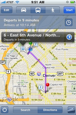
I have been meaning to blog for some time about how useful I find the transit information in Google Maps on the iPhone. It's been around for a while, but I have been using it quite a lot recently and haven't blogged about it before. For those who haven't used it, when you calculate directions you can pick one of three options: driving, public transit, or walking (you also have the same options on Google Maps online). When you choose public transit, it shows you the next available trip, as follows:

iPhone Maps Transit information

You can click on the clock icon to see later trips and alternative options. This is one example where the application knowing your current location really adds to the convenience of getting the information - you just choose where you want to go, from a search or your contacts, and then the default is to show you how to get there from your current location. Even if you know the route, being able to easily find the time of the next bus is a great convenience. Another nice aspect is that the GPS tracks the bus location as you travel, and shows the scheduled arrival time, making it easy to figure out where to get off, which is another potential source of stress when you're traveling on a route you don't know.
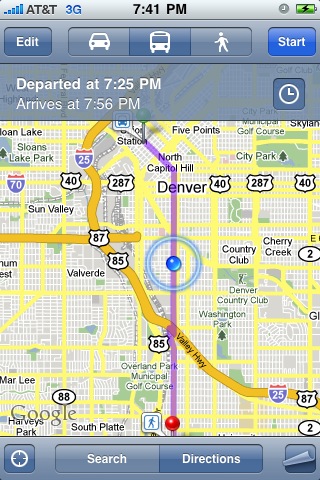
iPhone Maps Transit

I think that one of the main inhibitors to people using public transit when they're not used to doing it is just the effort of figuring out their options. In a lot of US cities like Denver the culture really isn't to use transit - the default option is just to take the car. We've had some new light rail lines opening over the past few years, with more being built, and a few more people use those, but very few people I know really think about using the bus here. But we actually have a very good bus system, even though many people don't realize it. I am fortunate to live downtown so most of the time I just walk when we go out in the evening, but increasingly if we go further afield I try to take the bus or the light rail, and a strong contributing factor to that is the convenience of figuring out the transit routes (which are often ones I haven't taken before, or at least don't take regularly) on the iPhone.

This is also available in Google Maps Mobile on other platforms apart from the iPhone. But it's only available for some cities - it depends whether the transit agency has made their data available to Google. So it works for example in Denver, and even in Cropston, the small village in Leicestershire in the UK where I grew up, but not (at the moment) in London or Washington DC.

Anyway, I think that mobile multi-modal transit routing applications like iPhone maps and others have great potential to encourage people to use public transit more. I encourage you to try it, and leave the car at home! Other iPhone applications that can supplement this include things like Taxi Magic, which lets you call a taxi to your current location, and car sharing schemes like zipcar, which now has a cool iPhone app (of which one of the niftiest features is that you can use your iPhone to unlock the car, or even honk its horn to help you find it!).

By the way, I only found out fairly recently how to capture iPhone screen shots - in case you don't know, to do this you hold down the "Home" button and at the same time press and release the power button, and this will save an image of the current screen in your Camera Roll photos. I found this out from the 9 year old son of Dale Lutz!

Monday, July 2, 2007

Issues with Google local search are on other platforms too

I played around with the local search capabilities on Google Maps Mobile on my BlackBerry 8800, and found that it also has the same issues that I discussed with local search on the iPhone. I guess I just hadn't used local search much with Google on my BlackBerry, as I'd been using Telenav which has richer functionality (in particular voice driving directions using the GPS).

Friday, June 22, 2007

Latest on Google Maps on the iPhone

Apple released today a twenty minute video showing more details on the user interface and capabilities of the iPhone, so we can all "get ready" for the launch next Friday. They talk about the maps application about three quarters of the way through. They say "one of the most useful tools available on the Internet today is maps (sic), and Google Maps on the iPhone is amazing". It does have a number of flashy user interface features that aren't available on other versions of Google Maps. A few quick observations from the demo. You can zoom in by double tapping or "pinching" the map (dragging two fingers apart), dragging with one finger will pan, and tapping with two fingers will zoom out. Of course the multi-touch interface is one of the most hyped features of the iPhone, and has been popular on other recently announced devices too (such as Microsoft's touch table). You can search for businesses by location using a single search field - in the demo they just type in "san francisco sushi". Pins fly in from the top of the screen to show each location. You can dial a restaurant that you've found, or get a route and show live traffic information. Of course it supports both imagery and street map views.

I had been deliberating about whether to get an iPhone, but think I've been seduced and will have to get one, despite its lack of GPS. Fortunately I have a group plan on Cingular (now AT&T) so I think I should be able to just add one more line to that group relatively cheaply, and keep my BlackBerry 8800 too. So I guess I'll be in line at the Apple Store in Denver on Friday next week - they go on sale at 6pm and there is no pre-booking or buying online (yet).

Adapx digital pen for paper input

One company that got a lot of attention at the ESRI User Conference was Adapx, who launched their application which allows you to use a paper map as an intelligent digital input device. John Calkins of ESRI demonstrated this in the plenary session with various other "cool things". Several others have blogged about this, including Joe Francica at All Points Blog, who includes a short video of a demo of the system. The underlying technology comes from a company called Anoto, who have been around for a while - I talked about this technology in a presentation at the GITA conference in 2004. The trick is that the paper is "watermarked" with a pattern of dots which allow the pen to determine its location in a very large coordinate space. One of the clever things about the solution is that the pen and paper is used not just for entering the location of geospatial features, but for other "user interface" actions such as specifying the type of feature to be captured. So you can click on a legend at the bottom of the map to say that you are about to add manholes (or whatever), and subsequent clicks will be treated accordingly. You can also capture attribute data using printed lists, or handwriting recognition. All of the intelligence to interpret these actions is applied when you upload the data, so the pen needs to store the sequence of events. This also means that if the system doesn't register a click on the legend, or registers the wrong item, you could get a significant amount of data captured incorrectly without the user realizing, as they have no real time feedback on what the system currently thinks they are doing. I guess time will tell whether this is a significant issue in practice or not. But certainly many field users will like the concept of being able to use paper and pen for input.

So it will be interesting to see whether this really takes off for widespread use. I think that one of the most promising uses is probably in areas where people currently use large paper maps or drawings in the field, such as on construction sites. It has always been a problem to provide the same capabilities on a laptop or tablet screen that you can get from a large paper construction drawing with a group of people standing round looking at it - you just don't have the real estate on a screen to show all that detail at one time, and share it with a group. The ability to mark up a map digitally in this situation could be very useful. Still for many work scenarios, for example where people visit lots of different locations which are not predefined, a digital display is likely to be more useful than having to carry very large numbers of paper maps.

But it's definitely an interesting alternative input mechanism in a number of scenarios, I look forward to seeing how it does in the market!