Showing posts with label geotagging. Show all posts

Wednesday, November 25, 2009

iPhone app review: flook is fun!

The past few days I have been playing around with flook, a new "location browser" application for the iPhone, and I like it. You can access some aspects of it in a regular browser, but it's really focused around the iPhone application. The basic idea is that users create "cards" with a photo, title and brief caption, together with a location, and you can browse for cards that are close to you. The user interface is very simple - you just swipe to go from one card to the next. The following is an example of one of my cards, featuring my local brewpub (which I live above):

Wynkoop on flook

The application is well designed, and has a fun and quirky feel to it. The following screenshot is an example - the oddball robots feature throughout the app.
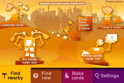
Flook application for iPhone

As flook starts up it gives you strange messages like "flook is snurging its capitulators" and "flook is polishing its locbots" (though I haven't seen that one much recently, so I guess my locbots must be pretty shiny!). Those still make me smile, though maybe the novelty will wear off at some point :).

So anyway, there's nothing very complex about the functionality, but that's part of the appeal too. It's simple but fun to use.

I think that two of the main challenges that the flook folks face are first, getting enough content in there to make it more interesting (it has just been released and I am the first user in Denver, so there is limited appeal to me in just browsing through my own cards, cool though they are ;)!). I have put in a couple of feature requests in regard to content creation, including the ability to more easily take my existing pictures from flickr and create cards from those (especially from photos which are already geotagged). The second big challenge, once they have a good volume of cards in the system, will be how to filter them effectively, to show you ones that are interesting to you.

There are a few things missing at the moment which I imagine will be addressed soon. One is the ability to find friends who are using flook, via the usual assortment of mechanisms like searching your contacts or Facebook friends. You can tweet from flook but I'd like a bit more control over how that works - currently there's just a global toggle which will cause a tweet to be sent whenever you create a new card (or not). I'd like a third option which would prompt you whether you want to tweet or not for each card, and give you the ability to edit the tweet message (currently it shows the title and caption from the card, with a link, which is a good starting point but depending on the situation I might like to tweet something a little different). The tweets are geo-located too, using the new geo feature of the Twitter API, which is cool. Flook has a scoring system, but at the moment there's no way to see how you rank, and nothing that I can see at the moment that promises to have that somewhat-silly-but-somehow-addictive quality of foursquare's mayor system.

The team behind flook has a strong pedigree from Psion / Symbian and they are well funded, so I think that while flook is clearly still in very early days, it will be an application to keep an eye on. If you have an iPhone, I recommend that you give it a try, it's fun!
Reblog this post [with Zemanta]

Thursday, January 29, 2009

Quick review of iPhoto 09 Places and Faces

I received my copy of Apple's new iLife 09 a couple of days ago, and being a keen photographer have spent quite a bit of time trying out the new features of iPhoto, especially Places and Faces. This is just a quick initial review - I may do a more detailed one in the next few days. Briefly, I very much like Places, with the exception of a few minor niggles, but Faces, despite an undeniable coolness when it correctly identifies someone, was overall a disappointment.

Places does a nice job of mapping geotagged photos. What I especially liked was the way that it clusters groups of photos that are close into a single pin on the map as you zoom out, and it breaks them out as you zoom it. Some other systems out there do this too, but most that I have tried have some issues (for example only displaying a limited number of pictures on a single map). I haven't done serious scalability testing so far, but have about 1700 geotagged photos on my world map so far and performance is good (these are a mixture of precisely geotagged photos with a latitude-longitude from a GPS stored in the photos' EXIF metadata, and others where I have just specified the city for a group of photos). It is easy to specify a location for a single photo or a group of photos, using Google search for geocoding so you can find the usual assortment of landmarks, businesses, etc as well as addresses. The system also generates a nice hierarchy of place names, so for example I can ask for all the photos in Stanley Park, Vancouver, British Columbia or Canada. There are some situations where the reverse geocoding doesn't find a name at some level of the hierarchy, and it uses a label of "Other", but overall this works well. Overall I think it's the nicest implementation of a system for viewing and managing geotagged photos that I have seen so far.

I really wanted to like Faces - the demo certainly looked really cool. I take a lot of photos and manage them in Aperture rather than iPhoto (I currently have 108,000 images in Aperture), and whenever I have time I tag the photos, including names of people in them. So good face recognition has the potential to be huge time saver. It's really cool when it works, and it does work well a good amount of the time, but overall it didn't work correctly sufficiently often that I'm not sure it is as fast as manually tagging names in Aperture. I will probably try to do a more systematic test of this impression over the weekend. There are two ways it can not work - it can find a face in the photo but not know who it is, or it can fail to find a face in the picture at all. The second case happened more often than I expected - it did very poorly with people wearing hats, large sunglasses, or with faces at an angle. Adding a face manually is a lot slower than doing a manual tag in Aperture (which can be a single key press for "favorite" tags, or a single drag and drop otherwise) - you have to click a button, drag to move a box, and drag again to resize a box, click a button, and type two or three characters of a name. There's also a confirmation process where you click to confirm that faces are who the system thinks they are, and (as far as I can tell) this has no ability to confirm multiple pictures at once (for example clicking on the first of a sequence and then shift-clicking on the last, as you normally do to select multiple items) - you have to click on each individual picture. The system could also be a lot cleverer about handling pictures that are taken in a sequence. It is very common with digital photography to take several photos of a group of people in a burst - and the date and time are stored so this situation is easy to identify. If you manually identify people in the first shot of a sequence, this should really carry through to other photos in the sequence, but it doesn't.

Also, as with iPhoto in general, Faces does not seem geared to handling large number of photos. I have 50+ people in my "Faces" already, a lot of whom just appear in a few photos, and there's no easy way to filter these down or organize them into groups etc, so it will be pretty unwieldy as I load more in there.

So overall, I think face recognition is a really exciting technology and it will be hugely useful in the future, but I don't think it's quite there yet based on my experience so far. In addition to improvements in the core recognition technology, there's a lot that Apple could do to make the workflow more efficient - it definitely has the feel of a "1.0" release (which is a little disappointing coming from Apple, with their strong focus on usability). I hope to see the face recognition capability come to Aperture soon though, hopefully with some improvements in the workflow for large volumes of pictures.

Tuesday, July 17, 2007

Back from Mexico - some experiences with geotagging

Well hello again, I am back from Mexico and had a great time. I managed to avoid blogging, the following was a more typical activity :)
Me reading my Jimmy Buffett book
This was my first vacation where I managed to reliably geotag all my photos - previously I had made a few half-hearted attempts but had failed to charge enough batteries to keep my GPS going consistently, or hadn't taken it everywhere. I used HoudahGeo to geotag the photos on my Mac, and this seemed to work fine, with a couple of minor complaints. One is that when it writes lat-long data to the EXIF metadata in the original images, for some reason iPhoto doesn't realize this, and doesn't show the lat-long when you ask for info on the photo (unless you export and re-import all the photos, in which case it does). The other is that most operations are fast, but for some reason writing the EXIF data to the photos, the final step in the workflow I use, is very slow - it would often take several minutes to do this for several hundred 10 megapixel images (a typical day's shooting for me), when the previous operations had taken a few seconds. But it did the job and all my photos have the lat-long where they were taken safely tucked away in their EXIF metadata.

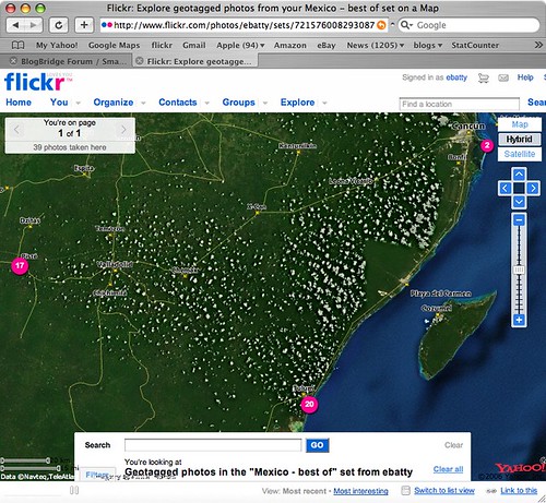
Flickr provides its own map viewing capability, which uses Yahoo! maps (not surprisingly since Yahoo! owns flickr). If you click here, you can see the live version of the map which is also shown in the following screen shot, showing the locations of my "top 40" pictures from the trip.
Flickr Map
If you zoom in to the northeast location, there is some high quality imagery, in Cancun, which gives a good basis for seeing where the photos were taken. However, the imagery is very poor in the two main locations where we stayed, Tulum (to the south) and Chichen Itza (to the west). I looked in Google Earth and Google Maps, and they both had much better imagery in Tulum, though unfortunately not in Chichen Itza. Microsoft didn't have good imagery for either location. So I thought I should poke around a little more to explore the latest options for displaying geotagged photos from flickr in Google Earth or Google Maps.

Flickr actually has some nice native support now for generating feeds of geotagged photos in either KML or GeoRSS. So this link dynamically generates a KML file of my photos with the tags mexico and best (though both Safari and FireFox don't seem to be able to recognize this as a KML file automatically, I have to tell them to use Google Earth and then it works fine). Unfortunately though, flickr feeds seem to return a maximum of 20 photos, and I haven't found any way around this. I can work around this by creating separate feeds for the best photos from Tulum, Chichen Itza and Cancun separately, but obviously that's not a good solution in all cases. These KML files work well in Google Earth, and one nice feature is that they include thumbnail versions of each photo which are directly displayed on the map (and when you click on those, you get a larger version displayed and the option to click again and display a full size photo back at flickr). However, the approach of using thumbnails does obscure the map more than if you use pins or other symbols to show the location of the photo - either approach may be preferred depending on the situation. These files don't display especially well in Google Maps - you get the icon, but the info window doesn't include the larger image or the links back to flickr - here's one example.

I looked around a little more and found this post at Ogle Earth which pointed me to this Yahoo Pipe which can be used to create a KML file from flickr. After a bit more messing around (you have to find things like your internal flickr id, which is non-obvious), I managed to produce this KML file which contains all of my "top 40" photos in a single file (you may need to right click the link and save the KML file, then open it in Google Earth). Of course I also needed to upload this file to somewhere accessible on the web, so all in all this involved quite a few steps. This KML file uses pins displayed on the map (with photo titles), rather than thumbnails, and again the info window displays a small version of the photo with an option to click a link back to flickr for larger versions. This KML also includes time stamps, which is interesting - if you are using Google Earth 4, you will see a "timer" bar at the top of the window when you select this layer. To see all the images, make sure you have the whole time window selected (at first this was not the case for me, so it seemed that some of the photos were missing). But if you select a smaller window, you can do an animation to show where the pictures were taken over time, which is also pretty cool.

So in general conclusion, the tools to easily geotag your photos are pretty solid now - I have used both HoudahGeo on the Mac, and previously RoboGeo on the PC, and both worked well. The software available to display geotagged photos is getting better, but there's still room for improvement - but I'm sure things will continue to move along quickly in this area. I would like to see flickr add a "KML" button to their map displays, which would be much simpler than the current process!

Thursday, July 5, 2007

Off on vacation for a week

I'm off to Mexico on vacation for a week from tomorrow morning, so don't expect too much blogging! We're staying in a cabana by the ocean with no electricity for four days, though they say they have a wireless network connection - not sure if that is good or bad :). If they really do then I may have to do one post from the outdoor bathtub before the iPhone batteries expire, just because I can ... but in general things will be quiet for a week or so!However, I did just buy myself a new Garmin 60CSx handheld GPS (since I still can't get any software I'm happy with to save tracklogs on the BlackBerry), and plan to test out the HoudaGeo application I just bought for the Mac to geocode all my photos (we will be going to the Mayan pyramids at Chichen Izta too, which I'm really looking forward to). I did a quick test of the HoudaGeo application in Denver this afternoon and it seemed to work fine (I had previously used RoboGeo on the PC, but that doesn't work on the Mac).

Cheers for now :).