If you haven't been to a mapping party before (or if you have!) I encourage you to come along. Last time we had a decent turnout, about 5 or 6 people each day, and we made some good progress on mapping downtown Denver.
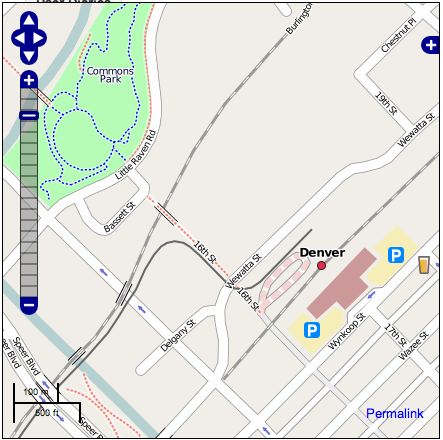
The screen shot above shows some details that you won't find in Google or Microsoft maps of Denver, including various footpaths and the light rail line. Click here for a live link. I hope we will finish up a pretty complete map of the downtown area at this level of detail over that weekend. And of course if you have other interests like cycle paths, etc, you are free to work on whatever you like! If you have any questions let me know. More information will be posted at Upcoming shortly.
2 comments:
Peter,
About the openstreetmap initiative, I would appreciate to know what you think about it?
- Because it is based on volunteers, it may appear that only main cities will be described? It may take ages to have a detailed enought map of the world?
- We are never about the quality and accuracy of data? Before using an information, it is important to know that it is up to date.
For the previous points, maps and data that are bought are supposed to be correct.
Thanks
Post a Comment