… than you can today, what compelling new things would this enable you to do? And yes, I mean 50 to 100 times faster, not 50 to 100 percent faster! I’m looking for challenging geospatial analytical problems that would deliver a high business value if you could do this, involving many gigabytes or terabytes of data. If you have a complex analysis that takes a week to run, but you only need to run it once a year for regulatory purposes, there is no compelling business value to being able to run it in an hour or two. But if you are a retail chain and you need to run some complex analysis to decide whether you want to buy an available site for a new store within the next three days, it makes a huge difference whether you can just run one analysis which takes two days, or dozens of analyses which take 30 minutes each, allowing you to try a range of assumptions and different models. Or if you’re a utility or emergency response agency running models to decide where to deploy resources as a hurricane is approaching your territory, being able to run analyses in minutes rather than hours could make a huge difference to being able to adjust your plans to changing conditions. There may be highly valuable analyses that you don’t even consider running today as they would take months to run, but which would have very high value if you could run them in a day.
If you have problems in this category I would be really interested to hear about them, either in the comments here, or feel free to email me if you prefer.
Update: I wanted to say that this is not just a hypothetical question, but I can't talk about any details yet. See the comments for more discussion.
Thursday, February 28, 2008
Friday, February 8, 2008
My GPS wins prestigious French neogeo award!
I was very honored to find that my Toyota Prius GPS navigation system received the award of "Le meilleur GPS de l’année" (best GPS of the year) from the French blog neogeo in their prestigious "le TopOfThePop Neogeo 2007" awards :). Je veux dire merci beaucoup, je suis très honoré!
The post has a pretty eclectic set of interesting links from la FrenchKissingMap to How I explained REST to my wife (or Comment j’ai expliqué REST à ma femme).
The post has a pretty eclectic set of interesting links from la FrenchKissingMap to How I explained REST to my wife (or Comment j’ai expliqué REST à ma femme).
Upcoming gigs
I have quite a few speaking engagements coming up, which have rather crept up on me, so I thought I'd give a quick summary.
Frugosapalooza, Denver, February 19: FRUGOS is the Front Range Users of Geospatial Open Source, and their one day "unconference" last summer was one of the best events I went to last year. Sean Gillies and I will both be speaking, but there will be plenty of time for networking and drinking :). We will even be honored by the presence of James Fee who is flying in from Phoenix for the event.
Panel for Joe Berry's GIS class, Denver, February 28: Joe has lined up an interesting panel for his class, and this event will be open to the public. Matt Ball will be talking about the role of GIS for sustainability, Bill Gail of Microsoft will be talking about the merging of real and fantasy in GIS, and I'll be talking about disruptive change in the industry. Tina Cary will be moderating.
FME User Conference, Vancouver, March 6: as I've mentioned previously, my friends at Safe Software kindly invited me to give the keynote at their worldwide user conference, and they recently put out a press release about this. A good thing about doing keynotes is that people have to say nice things about you for their advertising ;) ... you don't get too many keynote announcements saying "we've hired a really dull speaker with nothing interesting to say".
GITA Geospatial Infrastructure Solutions Conference, Seattle, March 11: I'm moderating a panel on "Mashups - Consumer Toy or Enterprise Tool?". We're still finalizing speakers for that one but I'm anticipating another good lineup.
Location Intelligence, Santa Clara, April 28: I'll be moderating the lightning talks on the opening afternoon of the conference, on the theme of Social Networking, Local Search and Location-based Advertising. I have cut short my attendance at the New Orleans Jazzfest by a day to do this, which tells you I expect it to be a good event :) !
Wednesday, February 6, 2008
Spatial Networking wins exit poll!
As I mentioned previously, last night at the Boulder Denver New Technology Meetup I gave the first public presentation and demo about what we're up to at Spatial Networking. There was a good turnout of around 200 people and I got a lot of questions and interest, so was pleased with how it went. And in the official exit poll, Spatial Networking was the clear winner :) ...
New Tech Meetup: Who Was Your Favorite? Exit Poll from gwenbell on Vimeo.
You can also read a writeup of the meeting at the Colorado Startups blog. And yes, I will explain much more about what we're up to here very shortly!
New Tech Meetup: Who Was Your Favorite? Exit Poll from gwenbell on Vimeo.
You can also read a writeup of the meeting at the Colorado Startups blog. And yes, I will explain much more about what we're up to here very shortly!
Wednesday, January 30, 2008
Coming out of stealth mode soon!
We have been making good progress on the application we are building at Spatial Networking, which in its initial release will run on the Facebook Platform. We plan to get an alpha release out to a small number of testers by the end of this week, and have a closed beta out within a few weeks after that. So I've decided it's time to start telling the world more about what we're up to, and I'll be doing this, and giving our first public demo, at next week's Boulder Denver New Technology Meetup Group, which is on Tuesday February 5 at 6pm in Boulder. I have found this to be a pretty interesting local group for anyone interested in technology startups. They had about 200 people at the last one. The general format is that 5 companies present for 5 minutes each (with 5 minutes for questions). So I'll have to be pretty concise, but I've been getting used to that with doing pitches to potential investors, who have pretty short attention spans :). If you're in the area please feel free to come to the Meetup, and if not I'll be posting much more information here in the coming weeks.
Tuesday, January 15, 2008
iPhone uses WiFi as well as cell signals to determine location
I just went out for a walk around my neighborhood in downtown Denver to test out the new "locate me" capability on my iPhone, and discovered something rather interesting: apparently the system is using not just cell phone signals but also WiFi to determine location, which explains the unexpectedly good first test result I mentioned in my previous post. I discovered this somewhat accidentally, but turning WiFi on and off on the phone made a big difference to accuracy. You do not have to be connected to a WiFi network in order to use WiFi for location determination.
Since I am in a WiFi-rich downtown location, using WiFi gives much more accurate results than triangulating cell phone signals. From a quick walk around the neighborhood here, I am consistently getting within half a block, or perhaps about 50 meters accuracy most of the time, and as good as 10-20m in some instances, when I have WiFi turned on. Of course it won't be nearly that good if you don't have a dense WiFi network, but this is much better than I expected. If I turned off the WiFi on the phone, the results were less accurate. It is a little hard to gauge the accuracy as the map display is zoomed out depending on the level of accuracy that the system thinks it can obtain (and there is a variable size circle displayed). But generally speaking, even without WiFi, the location generally seems to be within a block or two (say 100-200 meters) of the right location - though again this is in a downtown location with a high density of cell towers, so in a rural location it will be significantly less accurate.
If you look at Google's explanation of how "My Location" works, they only mention using cell tower location. I suppose that most of the other phones which have previously run Google Maps Mobile do not support WiFi, so this makes sense. Other vendors such as Navizon have used WiFi location for a while, and indeed they announced a version for the iPhone a little while ago (if you had hacked your phone, since of course it is still officially closed to third party applications at this point). But in general I haven't seen anything saying that Google was using WiFi for location determination.
I did find that the accuracy varied a fair amount from one attempt to another - I could stand on the same street corner and locate myself multiple times in quick succession, and get three different map scales (representing different accuracy levels) back. The true geo-geeks among you can check out this flickr album, which shows photos of the location given by my iPhone as I walked around the neighborhood, and each one is geotagged using my Garmin handheld, which gives a pretty accurate location. I have added various notes as I went through. On an individual photo you can click the map link to get an accurate view of where the photo was taken (you'll need to zoom in a little), and you can also see a map of the whole set.
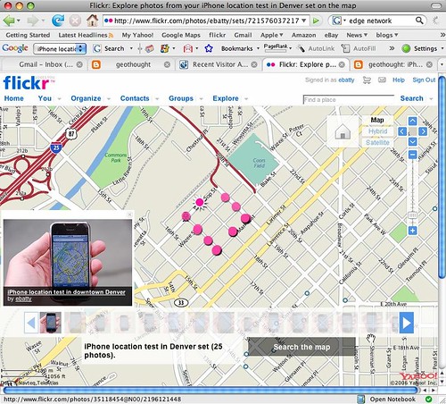
Anyway, in summary, I am very pleasantly surprised with the performance of the location capabilities so far - the use of WiFi gives a much higher accuracy than I had expected. Not good enough for in-car navigation applications, but definitely good for local search applications.
Update on my original post: Slashgeo reports that the WiFi positioning technology used in the iPhone is from Skyhook Wireless. One other comment I forgot to make before is that the location determination is pretty quick - typically 3-5 seconds for the map to refresh with the location, most of which is probably just the time to redisplay the map using the EDGE network.
Since I am in a WiFi-rich downtown location, using WiFi gives much more accurate results than triangulating cell phone signals. From a quick walk around the neighborhood here, I am consistently getting within half a block, or perhaps about 50 meters accuracy most of the time, and as good as 10-20m in some instances, when I have WiFi turned on. Of course it won't be nearly that good if you don't have a dense WiFi network, but this is much better than I expected. If I turned off the WiFi on the phone, the results were less accurate. It is a little hard to gauge the accuracy as the map display is zoomed out depending on the level of accuracy that the system thinks it can obtain (and there is a variable size circle displayed). But generally speaking, even without WiFi, the location generally seems to be within a block or two (say 100-200 meters) of the right location - though again this is in a downtown location with a high density of cell towers, so in a rural location it will be significantly less accurate.
If you look at Google's explanation of how "My Location" works, they only mention using cell tower location. I suppose that most of the other phones which have previously run Google Maps Mobile do not support WiFi, so this makes sense. Other vendors such as Navizon have used WiFi location for a while, and indeed they announced a version for the iPhone a little while ago (if you had hacked your phone, since of course it is still officially closed to third party applications at this point). But in general I haven't seen anything saying that Google was using WiFi for location determination.
I did find that the accuracy varied a fair amount from one attempt to another - I could stand on the same street corner and locate myself multiple times in quick succession, and get three different map scales (representing different accuracy levels) back. The true geo-geeks among you can check out this flickr album, which shows photos of the location given by my iPhone as I walked around the neighborhood, and each one is geotagged using my Garmin handheld, which gives a pretty accurate location. I have added various notes as I went through. On an individual photo you can click the map link to get an accurate view of where the photo was taken (you'll need to zoom in a little), and you can also see a map of the whole set.
Anyway, in summary, I am very pleasantly surprised with the performance of the location capabilities so far - the use of WiFi gives a much higher accuracy than I had expected. Not good enough for in-car navigation applications, but definitely good for local search applications.
Update on my original post: Slashgeo reports that the WiFi positioning technology used in the iPhone is from Skyhook Wireless. One other comment I forgot to make before is that the location determination is pretty quick - typically 3-5 seconds for the map to refresh with the location, most of which is probably just the time to redisplay the map using the EDGE network.
Location awareness on the iPhone is here
Well, the widely reported rumors were true, and today Apple released the 1.1.3 firmware update for the iPhone which provides location awareness, using cell phone triangulation. My first quick test had a much better result than I expected:
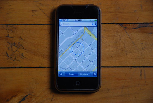
I am at home in my loft in downtown Denver and the center of the cross hair is pretty much exactly where I would have placed it on the map - within a few tens of feet of my location. I will do some more tests shortly, but it passed the first test well!
Incidentally, the photo above was automatically uploaded to flickr using my new-ish Eye-Fi card, which is a pretty cool gadget in case you haven't come across it. It's an SD card which includes Wi-Fi, and once you've done some setup, it will immediately upload pictures wirelessly to flickr or other online photo sharing services. I don't always want to do that, but for situations like this where you just want to take a photo and get it online quickly and easily, it's great!
Incidentally, the photo above was automatically uploaded to flickr using my new-ish Eye-Fi card, which is a pretty cool gadget in case you haven't come across it. It's an SD card which includes Wi-Fi, and once you've done some setup, it will immediately upload pictures wirelessly to flickr or other online photo sharing services. I don't always want to do that, but for situations like this where you just want to take a photo and get it online quickly and easily, it's great!
Subscribe to:
Posts (Atom)