
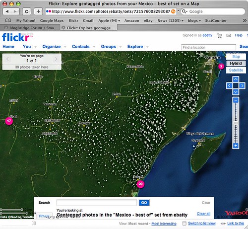
Flickr provides its own map viewing capability, which uses Yahoo! maps (not surprisingly since Yahoo! owns flickr). If you click here, you can see the live version of the map which is also shown in the following screen shot, showing the locations of my "top 40" pictures from the trip.
Flickr actually has some nice native support now for generating feeds of geotagged photos in either KML or GeoRSS. So this link dynamically generates a KML file of my photos with the tags mexico and best (though both Safari and FireFox don't seem to be able to recognize this as a KML file automatically, I have to tell them to use Google Earth and then it works fine). Unfortunately though, flickr feeds seem to return a maximum of 20 photos, and I haven't found any way around this. I can work around this by creating separate feeds for the best photos from Tulum, Chichen Itza and Cancun separately, but obviously that's not a good solution in all cases. These KML files work well in Google Earth, and one nice feature is that they include thumbnail versions of each photo which are directly displayed on the map (and when you click on those, you get a larger version displayed and the option to click again and display a full size photo back at flickr). However, the approach of using thumbnails does obscure the map more than if you use pins or other symbols to show the location of the photo - either approach may be preferred depending on the situation. These files don't display especially well in Google Maps - you get the icon, but the info window doesn't include the larger image or the links back to flickr - here's one example.
I looked around a little more and found this post at Ogle Earth which pointed me to this Yahoo Pipe which can be used to create a KML file from flickr. After a bit more messing around (you have to find things like your internal flickr id, which is non-obvious), I managed to produce this KML file which contains all of my "top 40" photos in a single file (you may need to right click the link and save the KML file, then open it in Google Earth). Of course I also needed to upload this file to somewhere accessible on the web, so all in all this involved quite a few steps. This KML file uses pins displayed on the map (with photo titles), rather than thumbnails, and again the info window displays a small version of the photo with an option to click a link back to flickr for larger versions. This KML also includes time stamps, which is interesting - if you are using Google Earth 4, you will see a "timer" bar at the top of the window when you select this layer. To see all the images, make sure you have the whole time window selected (at first this was not the case for me, so it seemed that some of the photos were missing). But if you select a smaller window, you can do an animation to show where the pictures were taken over time, which is also pretty cool.
So in general conclusion, the tools to easily geotag your photos are pretty solid now - I have used both HoudahGeo on the Mac, and previously RoboGeo on the PC, and both worked well. The software available to display geotagged photos is getting better, but there's still room for improvement - but I'm sure things will continue to move along quickly in this area. I would like to see flickr add a "KML" button to their map displays, which would be much simpler than the current process!
1 comment:
hi, it is good to read such articles like yours. Check out www.locr.com. It is an easy to handle website, that also enables geotagging for the most nokia mobile phones. So geotag your way of life
Post a Comment