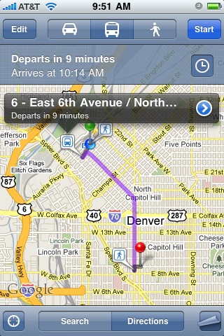
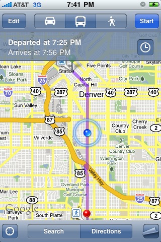
You can click on the clock icon to see later trips and alternative options. This is one example where the application knowing your current location really adds to the convenience of getting the information - you just choose where you want to go, from a search or your contacts, and then the default is to show you how to get there from your current location. Even if you know the route, being able to easily find the time of the next bus is a great convenience. Another nice aspect is that the GPS tracks the bus location as you travel, and shows the scheduled arrival time, making it easy to figure out where to get off, which is another potential source of stress when you're traveling on a route you don't know.
I think that one of the main inhibitors to people using public transit when they're not used to doing it is just the effort of figuring out their options. In a lot of US cities like Denver the culture really isn't to use transit - the default option is just to take the car. We've had some new light rail lines opening over the past few years, with more being built, and a few more people use those, but very few people I know really think about using the bus here. But we actually have a very good bus system, even though many people don't realize it. I am fortunate to live downtown so most of the time I just walk when we go out in the evening, but increasingly if we go further afield I try to take the bus or the light rail, and a strong contributing factor to that is the convenience of figuring out the transit routes (which are often ones I haven't taken before, or at least don't take regularly) on the iPhone.
This is also available in Google Maps Mobile on other platforms apart from the iPhone. But it's only available for some cities - it depends whether the transit agency has made their data available to Google. So it works for example in Denver, and even in Cropston, the small village in Leicestershire in the UK where I grew up, but not (at the moment) in London or Washington DC.
Anyway, I think that mobile multi-modal transit routing applications like iPhone maps and others have great potential to encourage people to use public transit more. I encourage you to try it, and leave the car at home! Other iPhone applications that can supplement this include things like Taxi Magic, which lets you call a taxi to your current location, and car sharing schemes like zipcar, which now has a cool iPhone app (of which one of the niftiest features is that you can use your iPhone to unlock the car, or even honk its horn to help you find it!).
By the way, I only found out fairly recently how to capture iPhone screen shots - in case you don't know, to do this you hold down the "Home" button and at the same time press and release the power button, and this will save an image of the current screen in your Camera Roll photos. I found this out from the 9 year old son of Dale Lutz!
3 comments:
Here in New York I rely on the public transit iPhone stuff every day (along with a brilliant app named Exit Strategy). Google's stuff is awesome and has worked brilliantly since it was introduced.
The slight issue is that with the subway you don't get updated on your progress along the route, nor can you alter your route whilst underground, but that's hardly a problem and I think there'll be cellphone extensions in the subway soon enough.
And you didn't know how to take screenshots?! Shame on you, Batty!!
I wonder if London isn't included because TFL has it's own very capable routing system? Probably some BS anti-compete clause in there. Wouldn't be so bad if they'd come up with an OSM iPhone app based off it, but have they?
(I have no idea - have they?)
I certainly agree with the idea that routing applications (working with temporal transit data) that run on mobile devices have the potential to encourage more people to use public transit. Often times it seems to be not to lack of public transit, but rather the lack of easily accessible current information about the transit options that turns off users.
Is limited transportation funding better spent on building new physical resources (i.e. bus lanes, light rail, etc), or in making more efficient use of the resources that we already have? Building useful informations systems that allow users to make informed transit choices would be at least an order of magnitude less expensive than constructing new transit systems. I'd be happy if both happened, but I'm guessing that spending on new information systems would be far more efficient, in terms of $ spent per rider gained.
Yes, london should be an option
Post a Comment