I did most of my testing using my WiFi connection, and then turned this off and used EDGE for a little while. Performance was excellent using the WiFi - it typically took around a second to download data for an uncached area, for either a street map or imagery, but up to two seconds or so occasionally, more so with imagery than street maps (which you would expect as the compressed images for street maps are typically smaller in size). The iPhone keeps a pretty good sized cache, and when data is cached display is pretty much instant, just as it is online. So overall the experience of panning and zooming around is very smooth and fast. Using EDGE instead of WiFi, I found that the download of data for an uncached area was generally taking around 3-4 seconds for street maps, and 5-7 seconds for imagery. But when data was cached, it was just as fast as with WiFi, as you would expect. So it was slower, but still fast enough to give a pretty good user experience, in my opinion. When zooming in or out, it animates the zoom using the data layer that is already there, so you see some sort of data while waiting for the data at the new scale to download.
The user interface for panning and zooming is intuitive once you learn the basics. Double tap to zoom in on a point (it doesn't center the point, but does keep that point on the screen - so if you double click on something in the northeast corner, after you zoom in it will still be in the northeast corner). Tapping with two fingers (at any distance apart and any orientation) will zoom out. You can also zoom in or out by "pinching" with two fingers and moving them closer together or further apart, which is a really intuitive interface which leverages the multi-touch capabilities.
One thing I really didn't like about the basic map display is that you can't rotate it. With other applications like the browser and photos, you just change the rotation of the iPhone from portrait to landscape, and the application automatically rotates the display (with a nice bit of animation). This is such a natural thing to want to do with a map display, I'm pretty disappointed that they didn't implement this - hopefully it will be there in a future release. This is one of multiple places where Google really didn't take advantage of some of the good features in other iPhone applications, and which makes for a less seamless and intuitive user experience as it doesn't do some things that you hope, and expect, it to do.
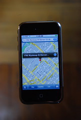
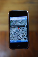
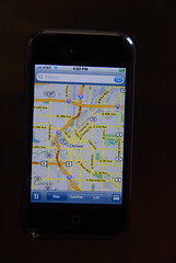
For the next set of observations, I took a pretty detailed set of photos which you can see here on flickr. Follow this through as a slide show to look at some search scenarios.
By and large, search worked pretty much as expected - you can type in a specific business name like "Tattered Cover" (my excellent local bookstore), or a generic term like "coffee", and get appropriate results back. But I did find a few things I hadn't anticipated, as follows:
- My search for the Tattered Cover yielded 3 incorrect locations, in addition to the (only) three correct ones. One was a location of an old store which closed a year ago, and two were the result of incomplete addresses for current stores (in addition to complete ones), one which just included the street with no number, and one which included the town but no street. I may have just been especially unfortunate with my choice of example, but this illustrates the importance of good and up to date data in any LBS application. An out of town visitor in the south side of Denver looking to visit the famous Tattered Cover bookstore could easily have driven to three locations, none of which had a Tattered Cover, by which point they would feel about Google Maps like I do about AT&T right now (see previous post)!
- Google Maps does not include the autocorrection feature for typing which is in all (or at least most) of the other iPhone applications. This is really bad. Typing is somewhat fiddly with the on screen keyboard, but you can go pretty fast if you have the autocorrect feature, and you get used to it in all the other applications. You have to type much more slowly and deliberately in Google Maps than anywhere else. This really needs fixing!
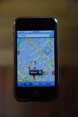
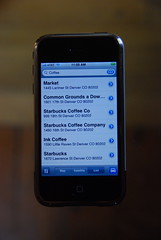
- When you search for items, it doesn't order them by distance from your location, neither does it show the distance to a search result in the list, which is very common in these type of applications and I think this is a serious omission too. On further investigation, I have come to the conclusion that the order in which results are returned is almost certainly determined by payment for higher placement - I found that the "Market" coffee store was consistently returned at the top of the list, and highlighted on the map, for a wide variety of different spatial queries in downtown Denver. This is not necessarily surprising - at some point Google needs to make some money back for all its investment in Google Maps and Earth, or it won't keep on investing - but it is good to know about. And if they remove the very useful function of showing how far away different search results are to hide the fact that they are (apparently) returning establishments which pay higher up the list, I'm not too happy about that. I will do a separate post about this as I think it's sufficiently interesting to highlight. You can see the detailed examples relating to this in the photo gallery.
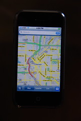
The real time traffic works well (I have the same thing on the BlackBerry also). Here are pictures showing central Denver, with and without traffic information, and you can see that the southbound carriageway of I-25 is currently congested.
The routing also seems to work well - in the picture gallery I show creation of a route from Denver to Vancouver, which was pretty much instantaneous, and you can list turn by turn directions either as text or on the map, and you can easily skip backwards and forwards in the turn list.
So general conclusion: I like the application, it's fast and intuitive in most regards, but does have a few things that need fixing. My order of priority on these would be:
- Needs to support autocorrection when typing
- Should be able to display search results in order of distance from the center of the screen (and show distances on the list) - even if this is an option, and the initial order is determined "at Google's discretion")
- The map display should rotate when you rotate the iPhone, as with other applications where this makes sense
10 comments:
Nice and thorough job Peter! You are one of the first with an interest in the gps and navigation possibilities. I did mention your review at www.gps-passion.net
Cheers, Ed
Hi, Peter. Excellent and thorough review of the new iPhone! Very informative!
I still come away though, realizing that what they've done is capture this entry-point with flying colors. By the time anyone attempts to catch-up with a similar interface, they'll have already captured the imaginations of the market, and as they always tend to do -- eventually upgrade the package to include the very things you'd rather see.
Judging by the initial reports on sales -- I'd say that my predictions are relatively accurate, and I know that the demographics aren't based entirely on the Maps utility present, but mostly the other aspects of the phone that that demographic really wanted in the first place.
To me, the use of Google Maps is just the icing on the cake, and I can easily see how and where it'll improve in its next iterations, and in time.
Hopefully, it ups the challenges of competition as well. It'd be nice to see some of the smartphone manufacturers get really serious about the mobile paradigm, for once.
By the way. Does your Blackberry plan charge you extra for maps use? Or is that bundled as an added charge? Just curious what your thoughts are on that, and how it's typically offered through most mobile plans.
PS:
I ask about the economics side to this concerning additional service charges because of the following.
I did the quick-math on this for myself, to see how I might benefit if I had an iPhone. My current plan with the unit I have, I'm paying typically $95 / month. (Of course I just had to have a mapping service, but I'm paying that added pad per month just to have the functionality!) And the Web? Oh, please. And to think I pay extra for that as well.
So looking at it as a consumer, and the reasons I'd look at a mobile unit like this... The phone costs roughtly $600. You pay around $55 per month.
I'm currently paying $95 per month. That totals to $1140 per year. The total for the first year with an iPhone would be $1260. Every year after that (depending on if service charge goes down or up) is roughly $660.
Hmmm. That iPhone is looking so much more attractive to me now.
Hi Daniel, on my BlackBerry (with AT&T/Cingular) I have used various map related applications, which I've previously blogged about. In general these use my unlimited data subscription (which gives me GPRS or EDGE) for $29.99 per month (on top of my voice plan) plus whatever mystery charges and taxes etc they add on. My current plan does not cover data access when abroad, I pay by the kB for that, but you can get a fixed price global plan too. Google Maps and BlackBerry Maps are free and just use this data plan. Telenav and Wisepilot charge a monthly subscription fee in addition to the data plan, which is around $10 a month. They both give voice-based turn by turn directions using the GPS.
Pritty cool, but google maps also works with any Java Phone :-) But really nice.
Alex, yes Google Maps Mobile runs on other mobile phones and the basic features are the same (see other posts on my BlackBerry 8800), but the user interface is significantly improved on the iPhone.
I just have to respond to the "user interface is significantly improved" bit. From your description, the only thing that the iPhone version has over the Treo version is tap-to-zoom and pinching. (The Treo uses the i and o buttons, or onscreen buttons, and you can tap to bring up information on a search result.) That's it? That's "significantly improved"?
Look, I'm glad the iPhone has Google Maps, and I'm glad it has a good UI. I just wish the Macolytes would stop acting like it's revolutionary stuff that's never been done on a phone before.
You might want to double-check that desire for an auto-rotating map feature.
I should mention that i have neither owned nor used an iphone, and the apex of my exposure has been a video presentation from apple's website. But i do own a motorcycle.
On a motorcycle, when you turn, you bank the bike. If you're using your iphone as a map, clipped onto the side of your motorcycle, you may wind up with a distracting, automatically-reorienting display (or you may not, if the centrifugal force keeps the iphone from registering that it's on its side).
That's not to say that i'd be against a configurable option.
Google Maps for iPhone and Google Maps in general suck. I can't tell what direction I'm going in until I start moving and then it's too late. I don't know how many times I've gotten lost using this thing. Now I understand that the rural area I live in probably doesn't have the most up-to-date info, but I've gotten lost in Pittsburgh with this thing. Part of the problem comes from the lag of AT&T's craptastic 3G network, but Google is to blame as well. Perhaps their new turn-by-turn Navigation software remedies these problems.
Hello,
thank you for the good article !
I have a question though :
how much data will Google Maps use for let's say getting directions from point A to point B ?
Thank you,
Post a Comment